Geodaten
Advertisement


Geodaten German Admin
The database contain geodata of the Federal Republic of Germany with geo referenced towns, municipalities, town quarters, administrative units, postal codes, telephone preselections, nature areas, landscapes, climatic zones. The data contain coordinates
Advertisement
Geodaten German Streets
For the area of the Federal Republic of Germany more than 1.5 million street coordinates with a coverage of 100% are available. The geo data offered here are in high-precision quality and are present in several coordinate and reference systems.
Geodaten German Houses (deutsch) v.1.00
For the area of the Federal Republic of Germany more than 19 million house coordinates with a coverage of 100% are available. The geo data offered here are in high-precision quality and are present in different coordinate and reference systems.
Geodaten International Streets (Deutsch) v.1.00
For many countries street coordinates are present with coverage degrees upto 100 percent. The geo data offered here are in high-precision quality and are present in different coordinate and reference systems.

Geodaten International Houses (English) v.1.00
For many countries house coordinates are present with coverage degrees upto 100 percent. The geo data offered here are in high-precision quality and are present in different coordinate and reference systems.

Geodaten International Houses (deutsch) v.1.00
For many countries house coordinates are present with coverage degrees upto 100 percent. The geo data offered here are in high-precision quality and are present in different coordinate and reference systems.

Geodaten German Streets (deutsch) v.1.00
For the area of the Federal Republic of Germany more than 2,7 million street coordinates with a coverage of 100% are available. The geo data offered here are in high-precision quality and are present in different coordinate and reference systems.

Geodaten Deutschland v.18.01
The database contain geodata of the Federal Republic of Germany with geo referenced towns, municipalities, town quarters, administrative units, postal codes, telephone preselections, nature areas, landscapes, climatic zones for proximity searches ec.

Geodaten International v.6.01
Geodata International - World-wide database of countries with georeferenced towns, municipalities, postal codes and administrative units with WGS84 and UTM coordinates and elevations for geocoding, proximity search, navigation, distance calculation.
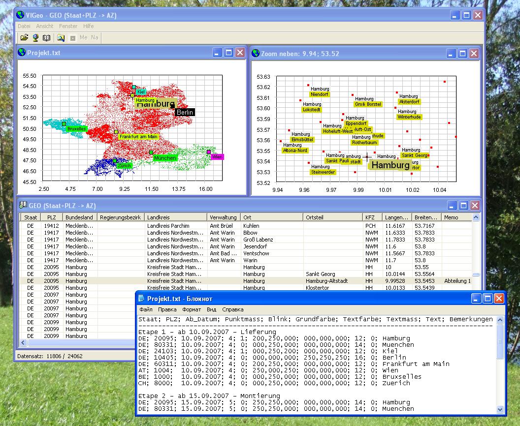
VIGeo v.1.1
Die Datenbank mit Geodaten (PLZ, KFZ etc) f+-r Deutschland, +lsterreich, Schweiz und Belgien.
TRANSDAT (English)
TRANSDAT Geosoftware executes coordinate transformations and geodetic datum shifts between lots of coordinate and reference systems of Germany, Europe, America, Australia and world wide. The current and historical coordinate and reference systems